The name “Teochew” is written in many ways. The variant we at The Teochew Store have chosen is the postal map spelling used in China during the republican era, as well as the standard form adopted in Singapore and Malaysia. However, literature out of Thailand generally stick to the spelling “Teochiu”, and those from Indonesia “Tiochiu”. Other variations that can be found on the Internet include “Diojiu”, “Taejiu” and “Tiuchiu”. These are all transliteration of the Chinese characters 潮州, which based on the Teochew “high language” spoken in the district’s prefectural city is pronounced diê-tsiu. At the same time “Teochew” is not infrequently represented in other language forms such as “Chiuchow” in Hong Kong Cantonese, “Trieuchau” in Vietnamese and of course “Chaozhou” in Mandarin (written in the past as “Chao-chow”).
Adding to the confusion, overseas Teochews who returned to their homeland after China re-opened its doors in the 1980s found that the region had adopted a new name – “Teo-swa” 潮汕. This name – derived by putting together “Teochew” and “Swatow” – was adopted after the historical Teochew prefecture was made defunct and replaced under Communist rule by an administrative unit centred on Swatow. As a result of the labours of the present government in China to promote Putonghua (Mandarin) and Hanyu Pinyin romanisation, recent English language pieces by writers in the mainland who are unfamiliar with old name Teochew, have designated the place by the appellation “Chaoshan” and its people the rather awful sounding “Chaoshanese”.
These are of course aberrations to Teochews who cherish their identity, and who know and appreciate its long of history. The name Teochew 潮州, literally the “Tidal Prefecture”, was adopted in 592 CE by the Sui dynasty on inspiration of the eternal flow and ebb of the South China Sea. That being said, the Teochew region actually first appeared on Imperial China maps as Kikyor 揭陽 (in Mandarin: Jieyang) county after the Han dynasty annexed the southern coast of China in 110 BCE. It was subsequently re-organised into a separate administrative area in 413 CE with the name Ngee Ann Commandery 義安郡, or the “Righteous Peace" Commandery.
The earliest Western literature in which Teochew was mentioned is possibly Juan González de Mendoza's The History of the Great and Mighty Kingdom of China and the Situation Thereof, which was first published in Spanish in 1586 as Historia de las cosas más notables, ritos y costumbres del gran reyno de la China and translated in English in 1588 by Robert Parke. Possibly the first full-length book on China published in Europe since the days of Marco Polo (who apparently visited Guangzhou in Guangdong and Quanzhou in Fujian but not Teochew), the collection of tales by Spanish travellers in the Far East spoke of Teochew as the home of the infamous pirate Limahong and gave its name as “Trucheo”.
It is probable that Juan González de Mendoza had learned about “Trucheo” from Teochew or Hokkien-speaking oral sources trading in Manila. However, Western navigation maps of China that appeared at around the same time marked the location of Teochew almost uniformly by various corruptions of its Mandarin name “Chaozhou”.
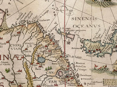
One of the earliest example is the map below (oriented with East direction on top) produced in 1598 by Jan Huygen van Linschoten, a Dutch acquainted with the Portuguese trade in the Orient. Here the Portuguese label “Chabaqueo” can be seen beside “I. de Lamao” (i.e. Namoa, or Nan’ao, island) and below right of “Chincheo” (Zhangzhou).